Day
1
3:30pm
Keflavik International Airport
Keflavík International Airport (Icelandic: Keflavíkurflugvöllur) (IATA: KEF, ICAO: BIKF), also known as ...
Keflavík International Airport (Icelandic: Keflavíkurflugvöllur) (IATA: KEF, ICAO: BIKF), also known as Reykjavík–Keflavík Airport, is the largest airport in Iceland and the country's main hub for international transportation. The airport is 1.7 nautical miles (3.1 km; 2.0 mi) west of Keflavík and 50 km (31 mi) southwest of Reykjavík. The airport has three runways, two of which are in use, and the airport area is about 25 km2 (9.7 sq mi). Most international journeys to or from Iceland pass through this airport.
The main carriers at Keflavík are Icelandair and WOW air, each of which has the airport as its main hub. The airport is almost exclusively used for international flights; most domestic flights use Reykjavík Airport, which lies 3 km (1.9 mi) from Reykjavík's city centre, although seasonal flights from Akureyri fly to Keflavík. Keflavík Airport is operated by Isavia, a government enterprise.
7pm
Blue Lagoon
A surreal experience soaking in the Blue Lagoon on a dark winter ...
A surreal experience soaking in the Blue Lagoon on a dark winter evening.
9pm
Bergás Guesthouse
Cosy guesthouse 20mins away from the airport. Perfect for 1-night stay to ...
Cosy guesthouse 20mins away from the airport. Perfect for 1-night stay to experience the Blue Lagoon (20mins away) without having to drive all the way to Reykjavik.
Day
2
8am
Seljalandsfoss
Seljalandsfoss is a waterfall in Iceland. Seljalandsfoss is located in the South ...
Seljalandsfoss is a waterfall in Iceland. Seljalandsfoss is located in the South Region in Iceland right by Route 1 and the road that leads to Þórsmörk Road 249. The waterfall drops 60 m (197 ft) and is part of the Seljalands River that has its origin in the volcano glacier Eyjafjallajökull. Visitors can walk behind the falls into a small cave.
10:30am
Skógafoss
Skógafoss (pronounced [ˈskou.aˌfɔs]) is a waterfall situated on the Skógá River in ...
Skógafoss (pronounced [ˈskou.aˌfɔs]) is a waterfall situated on the Skógá River in the south of Iceland at the cliffs of the former coastline. After the coastline had receded seaward (it is now at a distance of about 5 kilometres (3.1 miles) from Skógar), the former sea cliffs remained, parallel to the coast over hundreds of kilometres, creating together with some mountains a clear border between the coastal lowlands and the Highlands of Iceland.
1:30pm
Dyrhólaey
The small peninsula, or promontory, Dyrhólaey (0.192 Miles / 120 meters) (formerly ...
The small peninsula, or promontory, Dyrhólaey (0.192 Miles / 120 meters) (formerly known as "Cape Portland" by seamen) is located on the south coast of Iceland, not far from the village Vík. It was formerly an island of volcanic origin, which is also known by the Icelandic word eyja meaning island.
The view from Dyrhólaey is interesting: To the north is to be seen the big glacier Mýrdalsjökull. To the east, the black lava columns of the Reynisdrangar come out of the sea, and to the west the whole coastline in the direction of Selfoss is visible - depending on weather conditions. In front of the peninsula, there is a gigantic black arch of lava standing in the sea, which gave the peninsula its name (meaning: the hill-island with the door-hole).
In the summertime, many puffins nest on the cliff faces of Dyrhólaey.
3pm
Reynisdrangar Cliffs
4pm
Black Beach Suites
One of our best stays throughout the trip, set at the foot ...
One of our best stays throughout the trip, set at the foot of the mountain and just a short 5-minute from the Reynisdrangar Black Sand Beach. It has modern amenities (Netflix!) and a very clean kitchen, where you can cook after getting groceries from nearby Vik town centre.
6pm
Vik
Vík í Mýrdal, also known as Vík, is a village in South ...
Vík í Mýrdal, also known as Vík, is a village in South Iceland. Vík is a very small village, with about 300 inhabitants. Its importance comes largely from the fact that it's about half way along the south coast, and it's one of the few villages actually on the sandy beach that makes up most of the south coast of Iceland. The area is dominated by Mýrdalsjökull, the glacier which is home to Katla, one of Iceland's fiercest volcanoes. The village and the surrounding countryside are in constant danger of floods that might result from a potential volcanic eruption, which has been expected for many years now. On the other side of the village lies the Atlantic ocean which is treacherous in these parts, waves can be big and small boats easily get swallowed up if the crews are not experienced enough. While there is no reason to worry about the volcano if you're a tourist, you should be very careful going into the sea - there have been cases of tourists drowning when caught by waves on the beach near Vík.
Day
3
8am
Skaftafell
Skaftafell ( listen ) is a preservation area in Öræfi, southeast Iceland. ...
Skaftafell ( listen ) is a preservation area in Öræfi, southeast Iceland. It used to be a manor farm and a national park, but has been a part of Vatnajökull National Park since its establishment in 2008.
10am
Skaftafellsjökull
11am
Svínafellsjökull Glacier
12:30pm
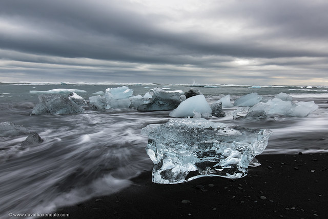
Jökulsárlón
Jökulsárlón is in southeast Iceland. Jökulsárlón literally means glacier lagoon (Jökull ...
Jökulsárlón is in southeast Iceland. Jökulsárlón literally means glacier lagoon (Jökull - glacier, lón - lagoon). At the time when first settlers arrived in Iceland, the edge of Breiðamerkurjökull, an outlet glacier of the great glacier Vatnajökull, is thought to have been 20km further north than it is now. The climate began to cool in about the year 1200, the cold spell reaching a peak in the period 1600-1900, which is sometimes known as the "Little Ice Age". As a result the glacier advanced until about 1890, reaching a point only about 1km from the coast at Jökulsá river. The eastern part of the glacier eroded the sediments of Breiðamerkursandur to a depth of up to 300m below sea level, the sediment being carried forward by the river Jökulsá. Without the river the glacier could not have eroded such a deep basin, because it is the river that carries the sediment to the sea.The warm period from 1920 to 1965 caused great changes in Breiðamerkurjökull glacier. It retreated very quickly, leaving a lagoon up to 190m deep where the glacier snout had been, and several kilometers of glacial moraines were exposed on both sides of the lagoon. The lagoon grew from 8km² in 1975 to 15km² in 1998. Large blocks of ice break off the edge of the glacier, which is about 30m high, keeping the lagoon stocked with icebergs.The lagoon, when frozen, was used in the 2002 James Bond film, Die Another Day, for a BMW chase scene.
3:30pm
Höfn
Höfn (pronounced something like "herpn", also known as Höfn í Hornafirði, is ...
Höfn (pronounced something like "herpn", also known as Höfn í Hornafirði, is a town in East Iceland, at the south-eastern corner of the country. Höfn sits by the lagoon (or fjord) Hornafjörður which is also the name of the large municipality of which the town is the centre and which covers the entire area of the county Austur-Skaftafellssýsla. This guide covers the town and the surrounding municipality, excluding the westernmost part which forms one of the main gateways to Vatnajökull National Park. For tourism purposes, the area calls itself the Vatnajökull Region: nowhere else is quite as dominated by Europe's largest glacier, nowhere else have people learned to live in such close quarters with the huge sheet of ice. In spite of substantial territory, the population of the Hornafjörður area is only around 2400. Höfn is by far the largest settlement with around 2000 inhabitants. The rest of the population is spread along the very narrow patch of arable land between Vatnajökull and the Atlantic Ocean. Höfn's economical activities mainly revolve around fisheries, and the town is especially known for lobster which can be found in abundant quantities in the fishing areas surrounding the southeastern coast.Despite its name which indicates a fjord, Hornafjörður is a very large lagoon with a blend of fresh and glacial water. The 40 square km lagoon is formed by interactions of the Atlantic Ocean and the Vatnajökull glacier, which by its constant movement produces clay and sand, carried by the glacier rivers and ending up as sediment in the lagoon. The lagoon is shallow, but nevertheless navigable by large ships and the town of Höfn (the name means harbour) is located at the first natural harbour on the south coast after Þorlákshöfn hundreds of kilometers to the west.The area is dominated by large mountains, wide rivers, and the ever-present Vatnajökull glacier. All of this has combined to make the area one of the most remote in Iceland until the last few decades of the 20th century when roads were significantly improved.
4pm
Seljavellir Guesthouse
Day
4
8am
Djúpivogur
Djúpivogur is a small town and municipality (Djúpavogshreppur) located on a peninsula ...
Djúpivogur is a small town and municipality (Djúpavogshreppur) located on a peninsula in the Austurland in eastern Iceland, near the island of Papey and on the fjord Berufjörður. The municipality was formed by the merger of rural communities Berunes, Buland, and Geithellur on October 1, 1992. The coastline consists of three fjords Berufjörður, Hamarsfjörður, and Álftafjörður. The town of Djúpivogur is located on a peninsula between Berufjörður and Hamarsfjörður.
Approximately 900m west of the town is a work of art named "Eggin í Gleðivík" (The Eggs of Merry Bay) by Sigurður Guðmundsson. The work is a replica of the eggs of 34 nesting birds in the area, and was installed in the summer of 2009.
11am
Fjardharheidhi
A beautiful mountain pass that leads to the most eastern part of ...
A beautiful mountain pass that leads to the most eastern part of Iceland
12:30pm
Seydisfjordur
Seyðisfjörður is a city in East Iceland.
Seyðisfjörður is a city in East Iceland.
2pm
Egilsstaðir
Egilsstaðir is the unofficial capital of ,East Iceland. Its population is 2332. ...
Egilsstaðir is the unofficial capital of ,East Iceland. Its population is 2332. It lies on the banks of the Lagarfljót river.
4pm
Sunnuhlíð Guesthouses
4pm
Akureyri
Akureyri, with a population of around 18,000, is the largest town in ...
Akureyri, with a population of around 18,000, is the largest town in Iceland outside the Southwest Iceland Southwest region, and the unofficial capital of North Iceland.
Day
5
9am
Goðafoss Waterfall
1pm
Akureyri
Akureyri, with a population of around 18,000, is the largest town in ...
Akureyri, with a population of around 18,000, is the largest town in Iceland outside the Southwest Iceland Southwest region, and the unofficial capital of North Iceland.
Day
6
9:30am
Varmahlíð
Skagafjordur is a municipality in North Iceland. It comprises of town of ...
Skagafjordur is a municipality in North Iceland. It comprises of town of Sauðárkrókur, the villages of Hofsós and Varmahlíð and several rural districts. It also includes the historic cathedral site of Hólar which is the site of a growing university today.
12pm
Blönduós
Blönduós is a small town at Húnaflói.
Blönduós is a small town at Húnaflói.
3:30pm
Reykjavík
Reykjavík is the capital and largest city of Iceland and with an ...
Reykjavík is the capital and largest city of Iceland and with an urban area population of around 200,000, it is the home to two-thirds of Iceland's population. It is the centre of culture and life of the Icelandic people, and is one of the focal points of tourism in Iceland. The city is spread out, and has sprawling suburbs. The city centre, however, is a very small area characterised by eclectic and colourful houses, with good shopping, dining and drinking. Reykjavik has the distinction of being the northernmost capital city in the world, though its winters are surprisingly mild for a city of its latitude.
4pm
City Park Hotel Reykjavik
8pm
Hallgrimskirkja
Hallgrímskirkja (Icelandic pronunciation: [ˈhatl̥krimsˌcʰɪrca], church of Hallgrímur) is a Lutheran (Church of ...
Hallgrímskirkja (Icelandic pronunciation: [ˈhatl̥krimsˌcʰɪrca], church of Hallgrímur) is a Lutheran (Church of Iceland) parish church in Reykjavík, Iceland. At 74.5 metres (244 ft) high, it is the largest church in Iceland and among the tallest structures in Iceland. The church is named after the Icelandic poet and clergyman Hallgrímur Pétursson (1614–1674), author of the Passion Hymns.
Day
7
11am
Geysir
Upcountry Árnessýsla, or Uppsveitir Árnessýslu in Icelandic, is a rural area in ...
Upcountry Árnessýsla, or Uppsveitir Árnessýslu in Icelandic, is a rural area in South Iceland, home to many of the country's most famous attractions. Upcountry Árnessýsla is one of the few places where arable land in Iceland reaches up to 50 km inland. As a result, it's one of the most important agricultural areas in Iceland. There are no major towns, however. The total population numbers a few thousand but only a few hundred live in the villages scattered around the area.The entire area lies in a geologically active belt with many interesting sights such as volcanoes, and geysers,. As a result of this and the proximity to Reykjavík it's one of the most popular tourist destinations in Iceland.
1:30pm
Gullfoss Falls
7:30pm
Reykjavik Chips
Day
8
9am
Keflavik International Airport
Keflavík International Airport (Icelandic: Keflavíkurflugvöllur) (IATA: KEF, ICAO: BIKF), also known as ...
Keflavík International Airport (Icelandic: Keflavíkurflugvöllur) (IATA: KEF, ICAO: BIKF), also known as Reykjavík–Keflavík Airport, is the largest airport in Iceland and the country's main hub for international transportation. The airport is 1.7 nautical miles (3.1 km; 2.0 mi) west of Keflavík and 50 km (31 mi) southwest of Reykjavík. The airport has three runways, two of which are in use, and the airport area is about 25 km2 (9.7 sq mi). Most international journeys to or from Iceland pass through this airport.
The main carriers at Keflavík are Icelandair and WOW air, each of which has the airport as its main hub. The airport is almost exclusively used for international flights; most domestic flights use Reykjavík Airport, which lies 3 km (1.9 mi) from Reykjavík's city centre, although seasonal flights from Akureyri fly to Keflavík. Keflavík Airport is operated by Isavia, a government enterprise.